My biggest problem was the cockpit itself... I knew it was going to be a difficult flight when I had trouble finding the gas tank switch.
I set up the rest of my flight instruments, and I thought that I set the GPS to point to Scribner airport, KSCB. More on that later.
My preflight and runup were uneventfully, and I got the reading for winds at KMLE. The were blowing 220 degrees at 11 knots. My runway choices were 30 and 12. As 220 is just 8 degrees off of 30, I was ready to go. I put the nose of the airplane down the runway and gave full throttle. I was instantly rewarded with the throaty growl of the engine and an instant push of speed. I was to 60 knots almost immediately and I rotated and pulled the airplane off of the ground.
One of the reasons I fly this airplane over the Cessnas that I could rent is that it has 180 horse, over the 150 of the typical Cessna 172. With only one person in the cabin, it really pulls.
View Larger Map
Millard Airport
As soon as I got in to the air, it was bumpy. Really bumpy. I turned left to 270 degrees and headed that way to play around with the navigation instruments to see if I could make everything work the way I wanted them to. I started having problems right away. Normally on a GPS screen you have a heading to where you are going, and your actual heading. Match the two up and you are on the right course. This particular airplane marrys up the GPS with the VOR needles so that you need only look at your VOR needle to steer the correct course.
The VOR works pretty simply. Tune in to the correct station on your navigation radio. Fly the course that you planned to go. Rotate your direction card so that the course to your destination is pointing at the top. The needle will show your deviation from that course. If the needle goes right you turn left to center the needle. If the needle drifts left you go left to center the needle. The VOR homes in on the radio signal that the VOR station is broadcasting, so regardless of where you have your direction card pointing the needle always points back to the station.
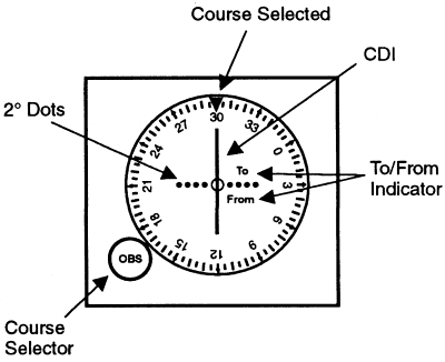
With the GPS married up to the VOR rather than the nav radio, the same principal was true, needle goes right you are deviating to the left, turn right to center the needle, you get the idea. The good news is that on long trips you would have to plan very carefully and tune in to many different VOR stations as you moved across the earth's surface. Sometimes, your destination would have spotty VOR coverage, and you would need to fly to various VOR stations just to get to your destination. Kind of like when you are driving. One road does not take you to where you want to go, you have to make various turns on various roads to get to your destination. VOR is the same way. With GPS, you can fly direct, and never have to tune in to a different VOR station.
My problem was I could not get my heading to show up on the GPS screen. I must have spent 15 minutes flying west trying to get the stupid GPS to work. All the while I am at relatively low altitude bouncing around in the various thermals at work. Not very fun. I finally found the screen where it displayed my heading and I matched that up with what I assumed was the course heading. It was different from what I had planed out, but with me flying so far to the west with I figured the GPS knew what it was doing.
I started gaining altitude now that that problem was fixed, and found that it was very comfortable at 4500 feet, as I was flying West, I chose that as my cruising altitude.
I turned on the connection with the GPS and the VOR needle so that I could practice flying using that. I thought that the connection was broken... The needle showed that I was way off course to the left. I turned off the connection so as not to be distracted... stupid needles... My numbers match, and the distance to destination was getting smaller so what did it know???
I started noticing that the distance to destination was moving very slowly... My ground speed read 100 knots so I knew that I was moving pretty quickly. Why was I not getting closer to KSCB? My numbers matched... Why was I not getting closer to KSCB? Then I noticed that the numbers started to get bigger... I was flying away from my destination. What the hell??? I then noticed that the number that I took to be the destination to heading was not the heading at all. The needle was correct. I was way off course to the left.
I made a right turn almost 100 degrees, and right there 10 miles away was the Scribner airport. I turned on my connection between the VOR and the GPS and now found that my CDI was centered.
It is never fun when you find out you are a moron.
KSCB does not have Automated Weather Observations (AWOS) so you have to find out the winds the old fashioned way. Get low and check out the wind sock.
You always fly out of the windsock, so you look to where the small end is pointing. You want to be in the same orientation. I had thought that I would use runway 17 because winds at KMLE were 220.
I practiced some go around procedures, then made a quick landing. I had messed around so much with the GPS that I did not have time now to sign the guest book... Maybe next time.
View Larger Map
Scribner Airport. Runway 17/35 is on the right hand side.
Now that I knew how to use the GPS it was a snap to get back to KMLE. I used the GPS and the VOR connection to great effect.
At about 10 miles to Millard I tuned in to the weather. The winds were very strange. They would blow for a while one direction, then die off and blow another direction. As I approached the airport one airplane took off from runway 30, then another airplane landed on runway 12. Kind of a dangerous situation. The good news was that everybody was having fun with it, and keeping their positions well communicated with everybody. As I turned off the weather I decided that runway 12 was my best bet, and somebody else just landed on that runway, so that was good enough for me...
I crossed mid-field at pattern altitude and set up on my downwind leg for landing. I was just turning final when I felt the wind change. I now had a slight tail wind, rather than the typical head wind. Not a bad thing, just different. Since I was on final already, I decided to land. I put down on the runway a bit too fast and had some fun working with cross winds as I kept my nose high to bleed off speed.
I absolutely hat this part of flying. You are almost fast enough to get airborne. Your nose is high so the airplane wants to fly. Your controls are sluggish, because they only work really well when you have enough speed. So you drift. I drifted, as everyone does, to the right as the cross wind was from the left.
I will have to sit down with an instructor to figure out how I can deal with that drift on the ground. I am sure that there is a better technique than I use.
No comments:
Post a Comment